


Geographic Information System
Description de Geographic Information System
L'application est un manuel gratuit complet de Geo Informatics System qui couvre tous les sujets importants avec des notes détaillées, des diagrammes, des équations, des formules et du matériel de cours.
Cette application contient 100 sujets avec des notes détaillées, des diagrammes, des équations, des formules et du matériel de cours, les sujets sont répertoriés en 5 chapitres. L'application est indispensable pour tous les étudiants en sciences de l'ingénieur
Téléchargez l'application en tant que matériel de référence et livre numérique pour les programmes et cursus d'ingénierie civile et autres.
L'application est conçue pour un apprentissage rapide, des révisions, des références au moment des examens et des entretiens.
Cette application couvre la plupart des sujets connexes et des explications détaillées avec tous les sujets de base.
Certains des sujets couverts dans cette application de système d'information géographique sont :
1. INTRODUCTION DU SIG
2. SIG au géocalcul
3. Facilitation technologique
4. FONCTIONNALITÉ DE BASE DU SIG
5. UNE DÉFINITION SYSTÉMIQUE DU SIG
6. La science SIG et l'essor de l'ingénierie de la géo-information
7. SCIENCE SIG À SUIVRE
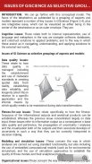
8. QUESTIONS DE GISCIENCE COMME GROUPEMENT SÉLECTIF D'ASPECTS
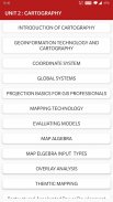
9. INTRODUCTION DE LA CARTOGRAPHIE
10. TECHNOLOGIE DE GEOINFORMATION ET CARTOGRAPHIE
11. SYSTÈME DE COORDONNÉES
12. SYSTÈMES MONDIAUX
13. BASES DE LA PROJECTION POUR LES PROFESSIONNELS SIG
14. ECHELLE CARTE
15. PROJECTION CARTOGRAPHIQUE
16. TRANSFORMATION GÉOMÉTRIQUE
17. DONNÉES VECTORIELLES ET RASTER
18. PHÉNOMÈNE SAPATIAL DU SIG
19. FONCTION DONNÉES SPATIALES
20. TECHNOLOGIES DE COLLECTE DE DONNÉES
21. TÉLÉDÉTECTION
22. ÉTUDE DE TERRAIN
23. Le rôle et la nature des modèles environnementaux
24. CONTEXTE DE LA MODÉLISATION ENVIRONNEMENTALE
25. RÉSUMÉ DU DÉVELOPPEMENT DU MODÈLE
26. APPLICATION DES MODÈLES
27. MODÉLISATION DES GLISSEMENTS DE TERRAIN
28. TOPOGRAPHIE DE MODÉLISATION
29. TYPOLOGIE DES MODÈLES
30. APPROCHES DE MODÉLISATION
31. REPRÉSENTATION ET CALCUL DES DYNAMIQUES GÉOGRAPHIQUES
32. MODÉLISATION TEMPORELLE
33. SIG TEMPOREL
34. CONCEPTS DE BASE DE DONNÉES
35. CONCEPTION DE LA BASE DE DONNÉES
36. TECHNIQUES DE SAISIE DES DONNEES
37. ENCODAGE DES DONNEES
38. SYSTÈME DE POSITIONNEMENT MONDIAL (GPS)
39. COMPARAISON DE L'ENCODAGE ET DU DÉCODAGE
40. MISE EN PAGE DES CARTES
41. ÉLÉMENTS DE MISE EN PAGE CARTOGRAPHIQUE
42. COMPLÉTER LES CARTES ET LES SÉQUENCES
43. TECHNOLOGIES DE SÉQUENÇAGE
44. TECHNOLOGIE DE CARTOGRAPHIE
45. MODÈLES D'ÉVALUATION
46. ALGÈBRE CARTOGRAPHIQUE
47. TYPES D'ENTRÉE MAP ELGEBRA
48. ANALYSE DE SUPERPOSITION
49. SUPERPOSITION VECTEUR ET RASTER
50. MODÉLISATION TARAIN
51. INTERPOLATION SPATIALE
52. FONCTION DE TRANSFERT
53. SIG & RÉSEAUX DE NEURONES ARTIFICIELS
54. RÉSEAUX
55. SIG ET ANALYSE DU RÉSEAU
56. APPLICATIONS AUX RESSOURCES EN EAU DU SIG
57. MODÉLISATION HYDROLOGIQUE
58. SIG ET SOCIÉTÉ
59. SIG ET TRANSPORT
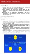
60. ÉVALUATION SIG DES CARACTÉRISTIQUES GÉOTECHNIQUES
61. OUVRAGES GÉOTECHNIQUES
62. GÉNÉRALISATION DES DONNÉES SPATAIL DANS LE SIG
63. CARTOGRAPHIE WEB
64. IMPORTANCE DE LA CONCEPTION BASÉE SUR LE WEB
65. ANALYSE D'IMPACT SUR L'ENVIRONNEMENT
66. SERVICE DE CARTE
67. CRÉATION ET DÉVELOPPEMENT DE SYSTÈMES DE SUIVI DE L'EPT
68. SIG DANS LA GESTION DES SERVICES PUBLICS
69. CARTOGRAPHIE THEMTIQUE
70. Développement restructuré-accéléré de l'électricité et réformes programmées
71. SIG DANS LA GESTION DES SERVICES PUBLICS
72. CARTOGRAPHIE THEMTIQUE
73. Développement restructuré-accéléré de l'électricité et réformes programmées
74. PHOTOGRAMMETRIE
75. CARTOGRAPHIE MOBILE
Tous les sujets ne sont pas répertoriés en raison des limitations de caractères.
Caractéristiques :
* Sujets complets par chapitre
* Mise en page riche de l'interface utilisateur
* Mode de lecture confortable
* Sujets d'examen importants
* Interface utilisateur très simple
* Couvrir la plupart des sujets
* Un clic pour obtenir tous les livres associés
* Contenu optimisé pour les mobiles
* Images optimisées pour les mobiles
Chaque sujet est complet avec des diagrammes, des équations et d'autres formes de représentations graphiques pour un meilleur apprentissage et une compréhension rapide.
Cette application sera utile pour une référence rapide. La révision de tous les concepts peut être terminée en quelques heures à l'aide de cette application.
Au lieu de nous donner une note inférieure, envoyez-nous vos questions, problèmes et donnez-nous une note et une suggestion précieuses afin que nous puissions en tenir compte pour les futures mises à jour. Nous nous ferons un plaisir de les résoudre pour vous.
Geographic Information System - Version 11.0
(10-09-2024)Geographic Information System - Information APK
Version APK: 11.0Package: engg.hub.geoinformatics.systemAncienne Version de Geographic Information System
Autres versions


 4.34
4.34


 3.17
3.17

Applications de même catégorie

Vous pourriez également aimer...


